Thursday, February 17, 2022

1913 Safford-Globe

Old postcards often give great history lessons.  The more you study them the more you find to study. Here is a card which led us on a long and merry path through yesteryear.
Above is the card which sparked this post.  It's actually a fairly common view of Fish Creek Hill on the Apache Trail south of Roosevelt Dam.  As of this writing there are five eBay listings which show this view.  So what makes this one so intriguing?  Well, read on and find out.
Our interest and subsequent intrigue was ignited on the back of the postcard.  Above you are looking at a gateway to all sorts of interesting historical trivia.  Let's start with the sender's simple script.
The sender might be "Carl" or "Carol."  For the purpose of this discussion, we'll say he was Carl. In any event, Carl was very anxious to tell Mamma in Safford that they didn't stop once on the way to Globe and passed 19 cars! Well, folks, this card was mailed in 1913 and seeing 19 cars on the Safford-Globe Road was a Very Big Deal!  First off, somebody (presumably Carl) had to actually count the cars they passed.  Counting cars in those days was common since cars were uncommon.  Sometimes just seeing ONE car was a Big Deal, let alone NINETEEN!

Since the card was postmarked on November 3rd (A Monday) we presume Carl & Party traveled on a Sunday.  That could help account for 19 cars passed.  The "Sunday Drive" ritual started early in American automotive culture. The 1913 time period was near the end of what's known as "The Brass Era" of automobiles.  The 19 cars passed must have been quite the sight to see.
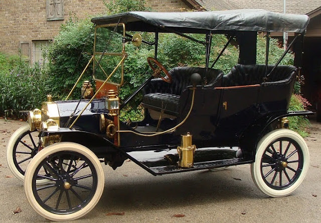
Above is a 1912 Model T.  The famous Model T was introduced in 1908 but hadn't really caught on yet. By the end of 1913, only about 2% of total Model T production had been built.  Henry Ford's game-changing assembly line wasn't even debuted until December 1913.  Headlights on the Model T above were lit with carbide gas produced by a generator on the driver's side running board. The lone tail light burned kerosene.
Many car owners in the 1913 era were prosperous and could afford to buy more powerful vehicles than a Model T.  This 1912 Moline would be typical of such a substantial auto of the era.  It had power, beefiness and lots of leg and elbow room for the passengers.  Chances are pretty good Carl observed a cavalcade of different brass era autos during the November 2, 1913, trip from Safford to Globe.
Source of photo: https://www.earlyamericanautomobiles.com/1912.htm
We don't have a good map of the road from Safford to Rice but we do have an accurate map of the Rice to Globe section of the road.  Chances are the Safford to Rice portion stayed as close as possible to The Gila River channel to avoid the steep arroyos in the adjacent alluvial fans.  The map above was produced by A.L. Westgard in 1910 and published in 1911 so it is quite likely that's the route Carl & Party traveled.

It's difficult to give a succinct link as a source for this map clip.  If you'd like to know more about it please contact me: arizonahistorystories@gmail.com
Now let's look at the November 3, 1913, postmark.  It's an RPO!!!  That means the Arizona & Eastern Railroad maintained a Railway Post Office car on their Globe to Bowie run.  This postcard was processed on Train #9.  We're hoping to find a timetable to determine when Train #9 operated.
The operation and history of RPO (Railway Post Offices) is a rich chunk of history unto itself. Untold numbers of postal enthusiasts actually collect RPO postmarks!  We've assembled some links to help you better understand RPO and how mail was transferred to and from a moving train during the long-running RPO Era. Most RPO mail cars had a drop slot so Carl probably just added his postcard directly to the car--knowing it would arrive in Safford the following day.

Some RPO links:


Now let's take a loot at the provenance of the postcard publisher.  PNC stands for "Pacific Novelty Company, an outfit based out of San Francisco and possibly New York, too.  PNC farmed out their postcards to Germany to be hand colored and printed.  The 1913 Era was at the peak of what's known as "The Golden Age of Postcards" made possible by low cost German expertise.  When World War One started in late June 1914, the German connection ended and a new phase of postcard production began.
For postcard history see: https://siarchives.si.edu/history/featured-topics/postcard/postcard-history
We've been unable to find much about the Pacific Novelty Company but that's the fun of Old Postcards.  The more difficult it is to find information about the card, the more we keep digging.
Scroll down this page for the source of this snippet PNC: http://www.metropostcard.com/publishersp1.html
PNC produced this postcard on behalf of H.P. Wightman in Globe.  Wightman ran a drug store.  Drug stores were THE place to go to buy postcards.  Wightman and his brother were successful Globe professional men who also maintained profitable mining investments.

https://www.newspapers.com/clip/95155789/hp-wightman-1906/

The above description of H.P. Wightman was clipped from a May 1906 Special Edition of "The Arizona Silver Belt" newspaper.  That edition also carried a description of his brother.  They sure sound like a Class Act.
Wightman's Brother: https://www.newspapers.com/clip/95155858/le-wightman-1906/

Fish Creek Hill and Canyon were widely considered to be THE highlight of The Apache Trail.  This is about the time that the Southern Pacific Railroad (parent of Arizona & Eastern) began offering a "detour" from Bowie to Globe and thence along The Apache Trail to Mesa.

Source of postcard:
https://www.ebay.com/itm/304356516350
Looking much closer at the postcard, we can spy out a remnant of a hand laid rock retaining wall.  Almost all of those walls were built by Apache Indians who were said to have natural skills at laying rocks by hand.  A few remnants of similar walls are visible on the old (now abandoned) Roosevelt-Payson Road.  (We successfully resisted the temptation to travel yet another tangent on the hand laid rock walls.  Whew!)

We added this postcard view to show you approximately where the circa 1913 view was located.

As everyone knows, Apache Trail is now closed and likely to remain so forever.  Ironically, the massive rockfall that closed the Trail happened almost right at the location of the scene shown in the 1913 postcard that spawned this post!

Source of photo: https://www.azbackroads.com/apache-trail/


Saturday, September 19, 2020

Tucson Circa 1905-1910

What is geo-locating? It's finding the location of an old photo. Where was the photographer standing? Which way was he looking? Geo-locating old postcard scenes is a fun but time-consuming pastime. However, it's rather rewarding when we can delve far enough into the past to pin precisely where a scene was located.  The photo above started us off 19SEP20 on a jaunt around Tucson's downtown area circa 1905-1910 when the Old Pueblo's population ranged from 10,000 to 20,000 hardy Territorial residents.  Even though most folks would be satisfied to know this scene showed "Congress Street Looking East" we wanted to know precisely WHERE on Congress Street???

Source:

Luckily we were able to find a 1907 postcard view of downtown Tucson looking toward the southeast.  After a careful study of this postcard we picked out an unmistakable telltale clue that tied this wide angle view to the first postcard of Congress Street.

Source: https://www.ebay.com/itm/Tucson-Arizona-1907-Birds-Eye/333724668508
Once you spot a building with a curved front façade, you have sufficient visual information to turn to every amateur historian's "go to" resource---The Sanborn Fire Maps!  Sources for both photos listed above.
Sanborn Fire Maps are an amazing, incredible resource.  They are easy to find at the Library of Congress.  The trick is in combing through their many pages to find just the "right match" for our quest. In this case, the curved front elevation of that building was all the clue we needed.

Source: https://www.loc.gov/item/sanborn00180_004/

Since we already knew the scene was from Congress Street all we had to do was look for a corner building with a curved front.  Presto!  There it is at the corner of Stone and Congress!  Therefore, by definition, the photographer's POV is geo-located near the middle of Congress Street slightly west of Stone Avenue.  A confirming clue is that the Sanborn Fire Map shows the Ivancovich Building which is prominent in the first postcard view.  Bingo!  We Got This!  

Source listed above.
Using that geo-location success story, we were then able to nail down how Congress Street and Stone Avenue appears in the 1907 Bird's Eye View.  The short line on left is Stone.  The long horizontal line is Congress.  East is left and west is right.  South is in front of you in this view.

Source listed above.
But what about those two gi-normous buildings showing in the downtown view.  Let's geo-locate them!

Source listed above.
To find further fun we turned to the 1909 Sanborn Fire Map.

Source: https://www.loc.gov/item/sanborn00180_005/
That first big white building in the red box at left was The famous Santa Rita Hotel located on the southeast corner of Scott and Broadway.  The Santa Rita vaulted Tucson into The Big Time.

Source: https://www.ebay.com/itm/Vignette-Postcard-Santa-Rita-Hotel-Tucson-AZ/192325879423
Over two thousand Tucsonians turned out for the February 1, 1904, Grand Opening of The Santa Rita.  The local newspaper raved about the place.  You can find and enlarge the above article here:

https://www.newspapers.com/clip/59585502/santa-rita-opening-coverage/

Interestingly, famed Southwest architect Henry Trost designed the Santa Rita AND the other building.

Yes, believe it or not, that other building in the far background in the right hand red box is the iconic Tucson Carnegie Library, also designed by Henry Trost.  Trost would go on to become a both a Living and Forever Legend in El Paso, Texas.  The Trost Society there keeps his legacy alive through prolific documentation and celebration of The Trost portfolio.

Source: https://www.ebay.com/itm/Vtg-Postcard-1903-Carnegie-Free-Library-Postcard-Tucson-AZ-Houston-El-Paso-RPO/274497374633

Trost Society: https://www.facebook.com/TrostSociety

While we were digging around on eBay for Old Pueblo street scenes we found this view of Congress Street looking east.  Of course, we already knew right where the photographer's POV was geo-located.


Another interesting challenge arose today when we found this postcard view labeled "Stone Avenue Looking South."  Once again, where the heck is it?  There are no obvious, telltale clues in this view to help us geo-locate the scene.

Source: https://www.ebay.com/itm/Tucson-Arizona-1912-Second-avenue-Looking-South/333724631797
So we turned to the priceless AZ Memory Project online digital archives.  Sure enuf, this view of Stone Avenue turned up and it's a close match to the above photo even though the archive date is wrong.  We enlarged it and cropped it.  At far left, you can see "Bells Drug" and across the street you can clearly see a "Cigars" sign.  Well, that's all we needed.

Source: https://azmemory.azlibrary.gov/digital/collection/histphotos/id/33021/rec/2
We turned to the always trusty Library of Congress Sanborn Fire Map and, after extensive searching, found a drug store across the street from a news and cigars store at Stone and Pennington.  BINGO!
The photographer's POV was therefore geo-located just north of Pennington from the middle of Stone looking south, of course.

Source cited above.
Aye, much work remains to be done but we're calling it a day today.  This little Sweetie has yet to be geo-located.  However, knowing what you've just learned here, perhaps YOU can find where the photographer stood when he created this timeless scene.

Source: https://www.ebay.com/itm/Tucson-Arizona-1900-10s-Stone-Avenue-looking-North/333724632522

Thanks for reading!  May your geo-location detective works always be successful!

John Parsons, Rimrock, Arizona.


Friday, September 18, 2020

Unusual Jerome View

Any given day on eBay, you can see about 300 Jerome postcards. Over 99% of those postcard views are "all the usual suspects" such as wide angle views of the entire town, street scenes and dilapidated buildings.  The postcard we discuss here is an uncommon view of the Jerome area. Comments are below each photo and graphic.

The above photo is not your typical Jerome postcard view.  Not at all.  In fact, it really doesn't even show the Jerome most people expect to see.  It looks out over Jerome High School to the toxic smoke belching from the Clarkdale smelter stacks several miles away.  Note the handwriting on the postcard.
Luckily, the eBay seller put up a high resolution scan of the postcard.  We were able to enlarge it to show the Jerome High School and the twin smelter stacks beyond. The toxic smoke was blamed for mass destruction of native vegetation, pastures and crops. Extensive litigation about the smoke impacts spanned years and resulted in the smelter's purchase of "smoke easements."  Those so-called easements were simply a license to kill the vegetation on the property of someone who sold an easement. The smelter smoke legacy is still a touchy issue with some in The Upper Verde Valley. Photographers of that era generally avoided showing the smoke plume.
In order for the Jerome High School to be in visual alignment with the Clarkdale smelter stacks, there is only one location from which the photo could have been captured--a point near Old US 89A's entrance to Jerome from the Mingus Mountain area.  Note that the handwriting on this picture matches the handwriting on the above photo of the smelter stacks.  It's 99% likely that it's the handwriting of famed,. prolific postcard photographer Burton Frasher.  Frasher visited Jerome often in the 1930's and 1940's.  Back then there wouldn't have been as much traffic as there is now so Frasher would have felt safe standing in the highway to record his photos.
We used Google Maps to create two views to show you where the photographer had to be positioned to get the smelter stacks photo.  The low end of the line would be the photographer's POV and the upper end would be the stacks.  The line goes right through the old high school.
Here's a closer view of the photographer's POV.  He would have been standing near the left end of the line.  The high school is at the right end of the line.  Jerome proper is to the left of the photographer's POV and totally out of view in the photo.
This 1943 photo of Jerome is a more more typical run-of-the-mill postcard view.  It's pretty much the stock-in-trade postcard view everyone expected to purchase and send.  It also is a very common postcard on eBay. We added the red arrow to show you where the photographer had to be positioned to get the smelter stacks to line up over the high school.

In some ways, the smelter stack photo is a very creative Jerome view. In addition to the bleak perspective of a cloud of toxic smoke, it shows the tenement, slum-like housing conditions in the low rent area adjacent to Jerome itself.

Here are the sources for the three postcards used in this post:


1913 Safford-Globe

Old postcards often give great history lessons.  The more you study them the more you find to study. Here is a card which led us on a long a...